Polar Vortex Weather Forecast – UK Cold and Snow Risks
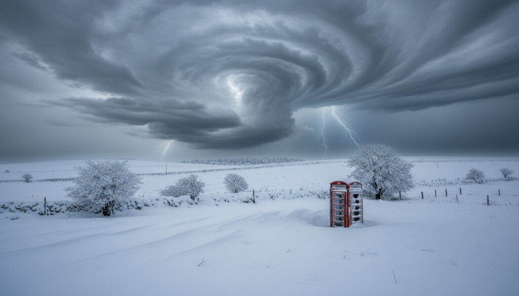
The Arctic stratosphere is undergoing a significant disruption that threatens to spill freezing air across the United Kingdom. A sudden stratospheric warming event confirmed in early February 2026 has destabilized the polar vortex, triggering forecasts of structural collapse and widespread cold outbreaks across the Northern Hemisphere.
Atmospheric monitoring indicates the vortex has reached a critical weakening phase, with temperature anomalies exceeding fifty degrees Celsius above normal at high altitude. For the UK, this translates into heightened probabilities of snow, ice, and prolonged freezing temperatures extending into early spring.
While the Met Office continues to monitor these stratospheric developments, understanding the current forecast requires examining the specific mechanics of the ongoing warming event and its projected timeline.
What is the latest polar vortex weather forecast for the UK?
The immediate forecast centers on a disrupted polar vortex sending Arctic air toward British shores. Current atmospheric modeling suggests the UK faces an elevated risk of northerly flows bringing freezing temperatures and disruptive snow through mid-to-late February 2026.
SSW event active since February 6, 2026; wind reversal underway
High probability of cold spells, snowfall, and freezing temperatures
Sudden Stratospheric Warming disrupting Arctic circulation patterns
Critical disruption expected through mid-February 2026
Key Insights
- Temperature anomalies exceeding 50°C above normal detected at the 10mb stratospheric level, according to Severe Weather EU
- Wind reversal reached “day 0” status early February, signaling imminent vortex structural change
- Forecast models anticipate the vortex splitting into two distinct cores by mid-February
- Greenland blocking high pressure expected to establish, driving northerly Arctic air toward the UK
- Low pressure systems projected to track across the Atlantic toward Europe, increasing snow risk
- No dedicated UK Met Office maps currently available for this specific event sequence
- Prolonged effects may persist into early spring 2026
| Fact | Details | Source |
|---|---|---|
| SSW Onset Date | February 6, 2026 | Severe Weather EU |
| Wind Reversal Status | Reached “day 0” (zero wind or reverse) | Severe Weather EU |
| Collapse Timeline | Mid-February 2026 (days 8-12 from onset) | Severe Weather EU |
| Temperature Anomaly | Over 50°C above normal at 10mb level | Severe Weather EU |
| UK Alert Status | “Deep freeze” and snow risk warnings | GB News |
| Vortex Configuration | Split into two cores anticipated | Severe Weather EU |
| US Early Effects | 30°F below normal temperatures | Severe Weather EU |
| Interfering Pattern | Madden-Julian Oscillation (MJO) active | Severe Weather EU |
| Met Office Specific Maps | Not available for this 2026 event | Met Office |
| Forecast Beyond February | No verified data available | Severe Weather EU |
Has the polar vortex collapsed?
The polar vortex has not fully collapsed as of early February 2026, though it has entered a critical weakening phase that forecasters expect to culminate in structural failure by mid-month. Atmospheric data confirms the vortex has slowed significantly, with stratospheric winds reversing direction at high altitude.
According to Futura Sciences, the circulation currently maintains integrity but faces imminent disruption. The transition from a single coherent vortex to a split configuration represents the collapse phase forecasters are monitoring.
Current Structural Status
Monitoring stations detected the onset of sudden stratospheric warming around February 6, 2026. This warming fundamentally alters the temperature gradient that drives the vortex’s circulation. As warm air intrudes into the polar stratosphere, the circulating winds that normally contain Arctic air weaken or reverse.
Data analyzed by Live Business Blog indicates the UK sits directly in the path of potential cold air outbreaks once the vortex splits. The “dislocated polar vortex” described by GB News refers to this exact phenomenon where Arctic air escapes its stratospheric confines.
Individuals sensitive to cold conditions should monitor local forecasts closely during vortex disruptions. For those wondering Why Am I Always Cold, polar vortex events can extend the duration of freezing temperatures significantly beyond typical winter patterns.
Timeline for Collapse
Forecast models project the full collapse or split will materialize approximately eight to twelve days following the initial warming event. With onset confirmed around February 6, this places the critical transition in mid-February 2026. The split will likely generate two separate vortex cores, with one positioned over North America and the other maintaining circulation near the pole.
When the polar vortex splits, the barrier containing Arctic air weakens significantly. This dislocation allows frigid air masses to migrate southward toward lower latitudes, potentially affecting the UK, Europe, and North America simultaneously.
What is the polar vortex forecast for the UK in 2026?
The 2026 forecast for the UK centers on the immediate February disruptions, with limited meteorological visibility beyond early spring. The current SSW event dominates the outlook, positioning Britain for significant cold exposure through mid-to-late February.
Immediate Cold Risks
Forecast models indicate a high probability of northerly polar air flows reaching the UK as the vortex disrupts. This pattern typically manifests as blocking high pressure over Greenland paired with low pressure systems tracking across the Atlantic toward Europe. The configuration directs Arctic air directly toward British shores, increasing risks of freezing temperatures, snow accumulation, and ice formation.
The Madden-Julian Oscillation currently interferes with global patterns, though according to Severe Weather EU, this factor temporarily shields parts of the central and eastern United States without altering European cold risks.
Prolonged Disruption Outlook
The effects of this SSW event may persist into early spring 2026. Meteorological analysis suggests that once split, vortex configurations often maintain weakened states for weeks, continuing to influence surface weather patterns even after the initial warming event subsides.
No verified data covers specific forecasts for dates beyond February 2026, including daily “tomorrow” predictions or April 2026 outlooks. Current monitoring focuses exclusively on the active mid-February disruption period.
What are the sudden stratospheric warming dates?
The 2026 sudden stratospheric warming event has followed a distinct chronological pattern of onset, amplification, and anticipated collapse. While exact daily forecasts remain unavailable, the established timeline provides clarity on critical transition phases.
When did the 2026 stratospheric warming events occur?
- : SSW onset detected with initial stratospheric wind slowing and temperature rise
- : Wind reversal reaches “day 0” as stratospheric winds hit zero or reverse direction, per satellite and balloon data analysis
- : Temperature anomalies peak at over 50°C above normal at 10mb level
- : Full polar vortex collapse or split anticipated (days 8-12 from onset)
- : Dual vortex cores establish, prolonged disruption continues
- : Residual effects of vortex disruption may persist per Severe Weather EU
What do we know for certain about the polar vortex?
Distinguishing between established atmospheric facts and forecast uncertainties helps calibrate expectations for the coming weeks.
| Established Information | Uncertain or Unavailable |
|---|---|
| SSW event confirmed active since February 6, 2026 | Specific daily forecasts for “tomorrow” or April 2026 |
| Temperature anomalies exceeded 50°C above normal at 10mb | Dedicated Met Office maps for this specific event sequence |
| Vortex split forecast for mid-February 2026 | Precise timing of cold air arrival in specific UK regions |
| UK faces elevated cold and snow risks | Confirmation of specific snow accumulation totals |
| MJO factor affecting North American patterns | Duration of effects beyond early spring |
| Two vortex cores expected to form | Exact wind speed measurements at all altitudes |
How does polar vortex disruption affect UK weather?
The polar vortex functions as a circulating barrier of low pressure and cold air surrounding the Arctic. When this circulation weakens or splits, the contained frigid air escapes its stratospheric confines, flowing southward toward Europe and North America.
For the UK specifically, a disrupted vortex often correlates with blocking patterns that force cold polar air across the British Isles. The Met Office explains that SSW events can trigger long spells of dry, cold weather for northern Europe as the jet stream shifts position.
The current 2026 event follows this established pattern, with forecast models showing Greenland high-pressure blocks that steer northerly flows directly toward Britain, potentially bringing conditions similar to those described in local forecasts for areas like the Weather Forecast High Wycombe region, where elevated terrain can amplify cold effects.
What are experts saying about the polar vortex?
Atmospheric scientists and meteorological agencies have provided specific technical context regarding the current disruption.
“Northern Europe can expect a long spell of dry, cold weather following sudden stratospheric warming events as the polar vortex weakens.”
— UK Met Office, General SSW Resources
The vortex has become “dislocated,” creating conditions for a deep freeze and significant snow across Britain.
— GB News, February 2026 Analysis
Reaching “day 0” status indicates the polar vortex winds have hit zero or reversed, triggering the collapse sequence.
What should UK residents expect from the polar vortex forecast?
UK residents should prepare for potential cold spells, snow, and freezing temperatures through mid-to-late February 2026 as the polar vortex undergoes collapse. While the Met Office continues monitoring through seasonal resources, specific daily forecasts require regular updates from official channels. Those in specific regions should consult local predictions such as the Weather Forecast High Wycombe for area-specific guidance.
Frequently Asked Questions
How does sudden stratospheric warming affect UK weather?
SSW events warm the Arctic stratosphere, reversing winds that contain cold air. This allows Arctic air to escape southward toward the UK, often causing blocking patterns that bring prolonged cold, dry conditions and snow risks to northern Europe.
Can I see a polar vortex forecast map for the UK?
No dedicated UK Met Office maps for the February 2026 event are currently available. Pressure anomaly forecasts from international monitoring show high-pressure systems splitting the vortex, but specific UK maps have not been released for this sequence.
What causes the polar vortex to weaken?
The vortex weakens when sudden stratospheric warming events disrupt the temperature gradient between the Arctic and mid-latitudes. Warm air intrusion into the polar stratosphere slows or reverses the circulating winds that normally contain frigid Arctic air.
How long will the 2026 polar vortex disruption last?
The disruption began February 6, 2026, with collapse expected mid-February. Effects may persist into early spring 2026, though specific durations remain uncertain as the vortex gradually reforms after splitting.
Does the Met Office predict snow for tomorrow?
No specific “tomorrow” forecasts or April 2026 daily predictions appear in available Met Office data. The agency provides general SSW guidance but not day-specific snow forecasts for late spring dates in the current monitoring cycle.
What is the Madden-Julian Oscillation?
The MJO is an atmospheric wave of enhanced rainfall and pressure changes that circles the tropics. During the February 2026 event, this oscillation temporarily shielded parts of the United States from cold while leaving European weather patterns exposed to vortex disruption.
More related posts
 From Paris with Love – Cast, Plot, Reviews and Where to Watch
 Dance Classes Near Me – LA’s Top Studios for 2025
 Martin Frizell Leaves This Morning: Why and What’s Next
 Chris Rock: Health, Diagnosis, Family, and Career Facts
 Daniel Radcliffe: Health, Family, Wealth, Life After Harry Potter
 How Many Calories Should I Eat to Lose Weight? Guide & Calculator
 You Season 5 Cast: All New & Returning Characters (2025)
 VW Polo for Sale in Ireland: Deals on DoneDeal, Carzone
